
Hadrian’s Wall
The emperor Hadrian visited Britannia in AD 122 and ordered his generals to build a wall from the Tyne to the Solway, to prevent raiders from the north destroying the strategic Roman base at Corbridge, in Northumberland.
According to restored sandstone fragments found in Jarrow which date from 118 or 119, it was Hadrian’s wish to keep “intact the empire”, which had been imposed on him via “divine instruction”. The fragments then announce the building of the wall. It is entirely possible that, on his arrival in Britain in 122, one of the stops on his itinerary was the northern frontier to inspect the progress of the building of the wall.
It was built in 5 mile stretches, with seventeen forts. Smaller forts called ‘milecastles’ were built every mile and between these were signal turrets. Hadrian’s Wall was 80 Roman miles or 117.5 km (73.0 mi) long; its width and height varied according to the construction materials that were available nearby. East of the River Irthing, the wall was made from squared stone and measured 3 metres (9.8 feet) wide and 5 to 6 metres (16 to 20 feet) high, while west of the river the wall was originally made from turf and measured 6 metres (20 feet) wide and 3.5 metres (11 feet) high; it was later rebuilt in stone. These dimensions do not include the wall’s ditches, berms and forts. The central section measured eight Roman feet wide (7.8 ft or 2.4 m) on a 3 m (10 ft) base. Some parts of this section of the wall survive to a height of 3 m (10 ft).
Building the wall was a huge undertaking; it took 15 years to build, and sons followed fathers into guarding the wall. Eighteen thousand soldiers worked on it, and 4 million tonnes of stone were used. It served as a frontier for several Roman incursions into Caledonia.
By AD 367 the wall was attacked by an alliance of tribes as part of the ‘Barbarian Conspiracy’. The Roman peace – ‘Pax Romana’ – was restored for a short time, but by AD 400 the Empire which had stretched from Newcastle to the Nile was in crisis and the frontier was abandoned.
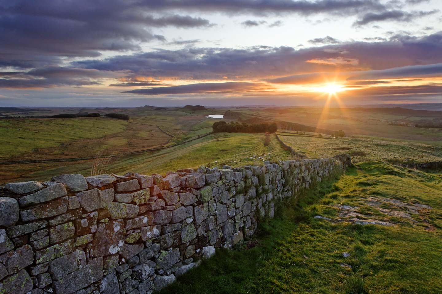
When in use it was effectively the northern limit of the Roman Empire.
Hadrian’s Wall Country has something for everyone – world class archaeology, spectacular landscapes, rare wildlife, complete solitude, vibrant cities, wonderful pubs and a population of friendly and welcoming people.
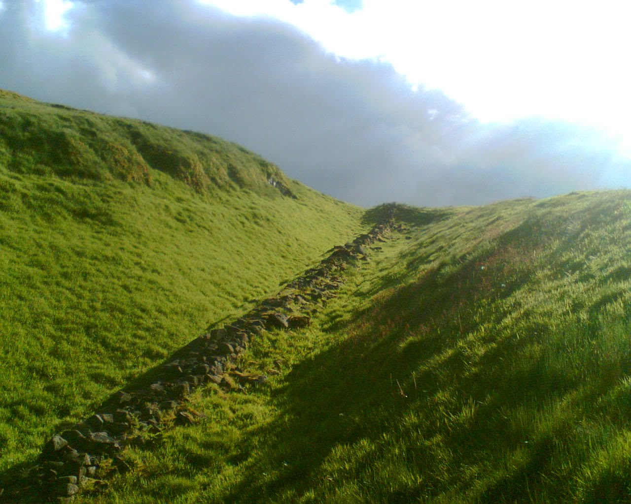
A significant portion of the wall still stands and can be followed on foot along the adjoining Hadrian’s Wall Path.
Immediately south of the wall, a large ditch was dug, with adjoining parallel mounds, one on either side. This is known today as the Vallum, even though the word Vallum in Latin is the origin of the English word wall, and does not refer to a ditch. In many places – for example Limestone Corner – the Vallum is better preserved than the wall, which has been much robbed of its stone.
 The limites of Rome were never expected to stop tribes from migrating or armies from invading, and while a frontier protected by a palisade or stone wall would help curb cattle-raiders and the incursions of other small groups, the economic viability of constructing and keeping guarded a wall 72 miles (116 km) long along a sparsely populated border to stop small-scale raiding is dubious.
Another possible explanation for the wall is the degree of control it would have provided over immigration, smuggling and customs. Limites did not strictly mark the boundaries of the empire: Roman power and influence often extended beyond the walls. People within and beyond the limes travelled through it each day when conducting business, and organised check-points like those offered by Hadrian’s Wall provided good opportunities for taxation. With watch towers only a short distance from gateways in the limes, patrolling legionaries could have kept track of entering and exiting natives and Roman citizens alike, charging customs dues and checking for smuggling. Another theory is of a simpler variety—that Hadrian’s Wall was partly constructed to reflect the power of Rome and was used as a political point by Hadrian. Once its construction was finished, it is thought to have been covered in plaster and then whitewashed: its shining surface reflected the sunlight and was visible for miles around.
Construction started in AD 122 and was largely completed in six years. Construction started in the east, between milecastles four and seven, and proceeded westwards, with soldiers from all three of the occupying Roman legions participating in the work. The route chosen largely paralleled the nearby Stanegate road from Luguvalium (Carlisle) to Coria (Corbridge), upon which were situated a series of forts, including Vindolanda. The wall in its central and best-preserved section follows a hard, resistant igneous diabase rock escarpment, known as the Whin Sill.
Early in its construction, just after reaching the North Tyne, the width of the wall was narrowed to 2.5 metres (8.2 feet) or even less (sometimes 1.8 metres) (the “Narrow Wall”). However, Broad Wall foundations had already been laid as far as the River Irthing, where the Turf Wall began, demonstrating that construction worked from east to west. Many turrets and milecastles were optimistically provided with wider stub “wing walls” in preparation for joining to the Broad Wall, offering a handy reference for archaeologists trying to piece together the construction chronology.
Within a few years it was decided to add a total of 14 to 17 full-sized forts along the length of the wall, including Vercovicium (Housesteads) and Banna (Birdoswald), each holding between 500 and 1,000 auxiliary troops (no legions were posted to the wall). The eastern end of the wall was extended further east from Pons Aelius (Newcastle) to Segedunum (Wallsend) on the Tyne estuary. Some of the larger forts along the wall, such as Cilurnum (Chesters) and Vercovicium (Housesteads), were built on top of the footings of milecastles or turrets, showing the change of plan. An inscription mentioning early governor Aulus Platorius Nepos indicates that the change of plans took place early on. Also, some time during Hadrian’s reign (before 138) the wall west of the Irthing was rebuilt in sandstone to about the same dimensions as the limestone section to the east.
 In the late 4th century, barbarian invasions, economic decline and military coups loosened the Empire’s hold on Britain. By 410, the estimated End of Roman rule in Britain, the Roman administration and its legions were gone and Britain was left to look to its own defences and government. Archaeologists have revealed that some parts of the wall remained occupied well into the 5th century. Hadrian’s Wall fell into ruin and over the centuries the stone was reused in other local buildings. Enough survived in the 8th century for spolia from Hadrian’s Wall to find their way into the construction of Jarrow Priory.
Much of the wall has disappeared. Long sections of it were used for roadbuilding in the 18th century, especially by General Wade to build a military road (most of which lies beneath the present day B6318 “Military Road”) to move troops to crush the Jacobite insurrection. The preservation of much of what remains can be credited to John Clayton. He trained as a lawyer and became town clerk of Newcastle in the 1830s. He became enthusiastic about preserving the wall after a visit to Chesters. To prevent farmers taking stones from the wall, he began buying some of the land on which the wall stood. In 1834, he started purchasing property around Steel Rigg near Crag Lough. Eventually, he controlled land from Brunton to Cawfields. This stretch included the sites of Chesters, Carrawburgh, Housesteads, and Vindolanda. Clayton carried out excavation at the fort at Cilurnum and at Housesteads, and he excavated some milecastles.
Although Hadrian’s Wall was declared a World Heritage Site in 1987, it remains unguarded, enabling visitors to climb and stand on the wall, although this is not encouraged, as it could damage the historic structure. On 13 March 2010, a public event Illuminating Hadrian’s Wall took place, which saw the route of the wall lit with 500 beacons. On 31 August and 2 September 2012, there was a second illumination of the wall as a digital art installation called “Connecting Light”, which was part of London 2012 Festival.
Hadrian’s Wall Path
The Latin and Romano-Celtic names of all of the Hadrian’s Wall forts are known, from the Notitia Dignitatum and other evidence such as inscriptions:
Segedunum (Wallsend)
Pons Aelius (Newcastle upon Tyne)
Condercum (Benwell Hill)
Vindobala (Rudchester)
Hunnum (Halton Chesters)
Cilurnum (Chesters aka Walwick Chesters)
Procolita (Carrowburgh)
Vercovicium (Housesteads)
Aesica (Great Chesters)
Magnis (Carvoran)
Banna (Birdoswald)
Camboglanna (Castlesteads)
Uxelodunum (Stanwix. Also known as Petriana)
Aballava (Burgh-by-Sands)
Coggabata (Drumburgh)
Mais (Bowness-on-Solway)
Turrets on the wall include:
Leahill Turret
Outpost forts beyond the wall include:
Habitancum (Risingham)
Bremenium (High Rochester)
Fanum Cocidi (Bewcastle) (north of Birdoswald)
Ad Fines (Chew Green)
Supply forts behind the wall include:
Alauna (Maryport)
Arbeia (South Shields)
Coria (Corbridge)
Vindolanda (Little Chesters or Chesterholm)
Vindomora (Ebchester)
This iconic tree was used as a location in the film Robin Hood Prince of thieves, and is a notable point in the midst of Hadrians Wall.

Antonine wall
Guerilla warfare by the Caledonians kept the Romans at bay after the battle of Mons Graupius. The Roman legionaries dismantled the fort at Inchtuthil, buried anything made of iron and marched south.
To keep the raiding tribes at bay, a new frontier was needed. This was the Antonine Wall, built in AD 142, by order of Emperor Antoninus Pius.
The wall, with its 19 forts, was the north-west frontier of the Roman Empire for about fifty years. It stretched from Bo’ness on the Forth to Old Kilpatrick on the Clyde. At 37 miles (60 km) in length, it had a stone base, with turf blocks, a wooden battlement on top, and a broad ditch on the north side. On the south side was the military road linking the 19 forts.
Construction was by detachments from the 2nd Legion based in Wales, the 6th at York, and the 20th at Chester – the same legions as had toiled on Hadrian’s Wall.
Records of their work in the form of stone ‘distance slabs’ are unique – nothing similar has been found elsewhere in the Roman world. In 2009 the Antonine Wall received protected status and is now a World Heritage Site.

Distance slabs from the Antonine Wall can be seen at the University of Glasgow’s Hunterian Museum, and the National Museum of Scotland in Edinburgh.
You can visit the remains of the Antonine Wall and museums along its route display artifacts including Roman coins, brooches and sandals. Antonine Wall artifacts can be seen at Kinneil Museum in Bo’ness, Callendar House Museum in Falkirk and The Auld Kirk Museum in Kirkintilloch
The Antonine Wall was a turf fortification on stone foundations, built by the Romans across what is now the Central Belt of Scotland, between the Firth of Forth and the Firth of Clyde. Representing the northernmost frontier barrier of the Roman Empire, it spanned approximately 63 kilometres (39 miles) and was about 3 metres (10 feet) high and 5 metres (16 feet) wide. Security was bolstered by a deep ditch on the northern side. It is thought that there was a wooden palisade on top of the turf. The barrier was the second of two “great walls” created by the Romans in Northern Britain. Its ruins are less evident than the better-known Hadrian’s Wall to the south, primarily because the turf and wood wall has largely weathered away, unlike its stone-built southern predecessor.
Construction began in CE 142 at the order of Roman Emperor Antoninus Pius, and took about 12 years to complete. It may be noted in passing that Antoninus Pius never visited the British Isles, whereas his predecessor Hadrian did, and may well have visited the site of his Wall, though this has not yet been proved.
Pressure from the Caledonians may have led Antoninus to send the empire’s troops further north. The Antonine Wall was protected by 16 forts with small fortlets between them; troop movement was facilitated by a road linking all the sites known as the Military Way. The soldiers who built the wall commemorated the construction and their struggles with the Caledonians in decorative slabs, twenty of which still survive. The wall was abandoned only eight years after completion, and the garrisons relocated back to Hadrian’s Wall. In 208 Emperor Septimius Severus re-established legions at the wall and ordered repairs; this has led to the wall being referred to as the Severan Wall. The occupation ended a few years later, and the wall was never fortified again. Most of the wall and its associated fortifications have been destroyed over time, but some remains are still visible.
Roman Emperor Antoninus Pius ordered the construction of the Antonine Wall around 142. Quintus Lollius Urbicus, governor of Roman Britain at the time, initially supervised the effort, which took about twelve years to complete. The wall stretches 63 kilometres (39 miles) from Old Kilpatrick in West Dunbartonshire on the Firth of Clyde to Carriden near Bo’ness on the Firth of Forth. The wall was intended to extend Roman territory and dominance by replacing Hadrian’s Wall 160 kilometres (99 miles) to the south, as the frontier of Britannia. But while the Romans did establish many forts and temporary camps further north of Antonine’s wall in order to protect their routes to the north of Scotland, they did not conquer the Caledonians, and the Antonine Wall suffered many attacks. The Romans called the land north of the wall Caledonia, though in some contexts the term may refer to the whole area north of Hadrian’s Wall.
There was once a remarkable Roman structure within sight of the Antonine Wall at Stenhousemuir. This was Arthur’s O’on, a circular stone domed monument or rotunda, which may have been a temple, or a tropaeum, a victory monument. Sadly it was demolished for its stone in 1743, though a replica exists at Penicuik House.
The wall was abandoned only eight years after completion, when the Roman legions withdrew to Hadrian’s Wall in 162, and over time may have reached an accommodation with the Brythonic tribes of the area, whom they may have fostered as possible buffer states which would later become “The Old North”. After a series of attacks in 197, the emperor Septimius Severus arrived in Scotland in 208 to secure the frontier, and repaired parts of the wall. Although this re-occupation only lasted a few years, the wall is sometimes referred to by later Roman historians as the Severan Wall. This led to later scholars like Bede mistaking references to the Antonine Wall for ones to Hadrian’s Wall.
 The Antonine Wall, also called Vallum Antonini, ran between the estuaries of the rivers Forth and Clyde in what is now Scotland. It had a stone foundation with a turf wall on top. Each two miles there was a fort. From north to south the wall had a ditch, wall and military road. It lacked a rear ditch system like the Vallum on Hadrian’s Wall.
In medieval histories, such as the chronicles of John of Fordun, the wall is called Gryme’s dyke. Fordun says that the name came from the grandfather of the imaginary king Eugenius son of Farquahar. This evolved over time into Graham’s dyke – a name still found in Bo’ness at the wall’s eastern end – and then linked with Clan Graham. Of note is that Graeme in some parts of Scotland is a nickname for the devil, and Gryme’s Dyke would thus be the Devil’s Dyke, mirroring the name of the Roman Limes in Southern Germany often called ‘Teufelsmauer’. Grímr and Grim are bynames for Odin or Wodan, who might be credited with the wish to build earthworks in unreasonably short periods of time. This name is the same one found as Grim’s Ditch several times in England in connection with early ramparts: for example, near Wallingford, Oxfordshire or between Berkhamsted (Herts) and Bradenham (Bucks). Other names used by antiquarians include the Wall of Pius and the Antonine Vallum, after Antoninus Pius. Hector Boece in his 1527 History of Scotland called it the “wall of Abercorn”, repeating the story that it had been destroyed by Graham.
World Heritage status
The UK government’s nomination of the Antonine Wall for World Heritage status to the international conservation body UNESCO was first officially announced in 2003. It has been backed by the Scottish Government since 2005 and by Scotland’s then Culture Minister Patricia Ferguson since 2006. It became the UK’s official nomination in late January 2007, and MSPs were called to support the bid anew in May 2007. The Antonine Wall was listed as an extension to the World Heritage Site “Frontiers of the Roman Empire” on 7 July 2008. Though the Antonine Wall is mentioned in the text, it does not appear on UNESCO’s map of world heritage properties.
Several individual sites along the line of the wall are in the care of Historic Scotland. These are:
Bar Hill Fort
Bearsden Bath House
Castlecary
Croy Hill
Dullatur
Rough Castle
Seabegs Wood
Watling Lodge
Westerwood
