So I have to inform you that some of the pictures used in this post will include nudity. Nothing over the top and only drawings of pict people.
“Venit et extremis legio praetenta Britannis, Quae Scotto dat frena truci ferronque notatas Perlegit examines Picto moriente figuras”
The above words of the Roman poet Claudian perhaps give the only physical description of the race of people known as Picts who once raided Roman Britain, defeated the Anglo-Saxon invaders and in one of the great mysteries of the ancient world, disappeared as a separate people by the end of the tenth century.
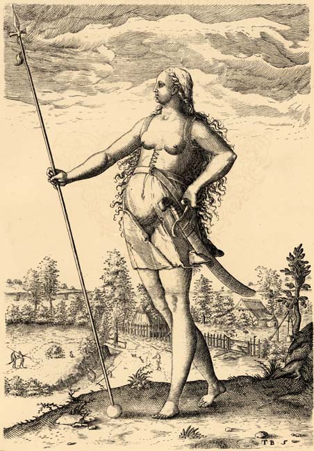
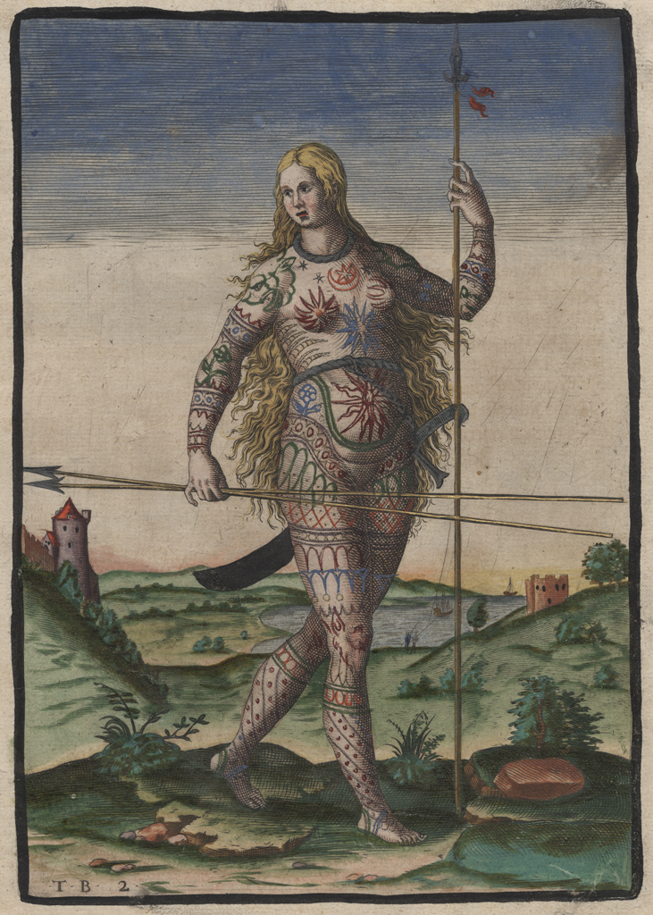
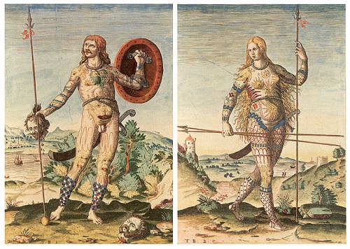
“This legion, which curbs the savage Scot and studies the designs marked with iron on the face of the dying Pict,” are the Claudian words which give some insight as to the name given by Rome to the untamed tribes north of Hadrian’s Wall . The Romans called this pre-Celtic people Pictii, or “Painted,” although Claudius’ words are proof that (as claimed by many historians), the ancient Picts actually tattooed their bodies with designs. To the non-Roman Celtic world of Scots and Irish and the many tribes of Belgic England and Wales they were known as “Cruithni” and for many centuries they represented the unbridled fury of a people who refused to be brought under the yoke of Rome or any foreign invader.
Some historians now believe that the Romans may have simply misheard the name ‘Pecht’ or ‘Pect’. In Old Norse the Picts were called the Péttir, Péttar or Peti. Old English names included Pehtas and Peohtas.
The origins of the Picts are clouded with many fables, legends and fabrications, and there are as many theories as to who the Picts were (Celtic, Basque, Scythians, etc.), where they came from, what they ate or drank, and what language they spoke, as there once were Pictish raiders defying the mighty legions of Rome. Legend tells us, perhaps incorrectly, that Rome’s mighty Ninth Legion, the famous “Hispana” legion, which had earned its battle honors in Iberia, conquering Celtic Spain for Caesar is never heard of again when faced against the Picts (they actually surfaced years later in Israel). We do know that the Picts may have spoken a non-Celtic language, (although many Celtophiles feel the Picts spoke a Brythonic-Gaulish form of Celtic language) as St. Columba’s biographer clearly stated that the Irish saint needed a translator to preach to the Pictish King Brude, son of Maelchon, at Brude’s court near the shores of Loch Ness. At other times the Pictish king lived at Scone, and we know there often were two separate Pictish kingdoms of Northern and Southern Picts. We know that they were mighty sailors, for the Romans feared the Pictish Navy almost as much as the wild men who came down from the Highlands to attack the villages along the wall. We also know that as far as the 9th century they wrote in stone a language which was not far in design from the Celtic “Ogham” script but was not Celtic in context. By the legacy of their standing stones, we know that they were great artists as well. It is also well known that the Picts were one of Western culture’s rare matrilinear societies; that is, bloodlines passed through the mother, and Pictish kings were not succeeded by their sons, but by their brothers or nephews or cousins as traced by the female line in a complicated series of intermarriages by seven royal houses.
It was this rare form of succession which in the year 845 A.D. gave the crown of Alba and the title Rex Pictorum to a Celtic Scot, son of a Pictish princess by the name of Kenneth, Son of Alpin. This Kenneth MacAlpin, whose father’s kingship over the Scots had been earlier taken over by the Pictish king Oengus, who ruled as both king of Picts and Scots, and who possibly harbored a deep ethnic hatred for the Picts, and in the event known as “MacAlpin’s Treason” murdered the members of the remaining seven royal houses thus preserving the Scottish line for kingship of Alba and the eventual erasure from history of the Pictish race, culture and history.
The true mystery in Pictish studies is the extraordinary disappearance of the culture of the tattoed nations of the North. The fact that within three generations of MacAlpin kings, the Picts were almost held in legendary status as a people of the past must be the real question to be answered, and the historian is consumed by legend, lack of facts and the nagging story of an obscure intrigue leading to genocide of a people, its customs, culture, laws and art.
It is in the sculptured stones of Scotland, left behind by the Pictish and proto-Pictish people of ancient Alba and present day Scotland that we can find some information about a mighty race of people who defied and defeated Rome and who slaughtered the invincible barbarian hordes of Angles Germans at Nechtansmere in Angus, and hammered the invading Vikings back home thus forever preserving a separate culture and race in Scotland. It is in these sometimes mighty, sometimes delicate stones that the history of ancient Scotland is now recorded. Were they descendants of the ancient Basque people of northern Spain once known to Rome as Pictones, who then migrated to northern Britain after they had helped the Empire defeat the seagoing people of Biscay? Or are they descendants of the dark tribes of ancient Stygia and the huge Eastern steepes? No one knows – only the Stones.
Early Pictish religion is presumed to have resembled Celtic polytheism in general, although only place names remain from the pre-Christian era. When the Pictish elite converted to Christianity is uncertain, but traditions place Saint Palladius in Pictland after he left Ireland, and link Abernethy with Saint Brigid of Kildare. Saint Patrick refers to “apostate Picts”, while the poem Y Gododdin does not remark on the Picts as pagans. Bede wrote that Saint Ninian (confused by some with Saint Finnian of Moville, who died c. 589), had converted the southern Picts. Recent archaeological work at Portmahomack places the foundation of the monastery there, an area once assumed to be among the last converted, in the late 6th century. This is contemporary with Bridei mac Maelchon and Columba, but the process of establishing Christianity throughout Pictland will have extended over a much longer period.


Perhaps the greatest mystery of Scottish or even European history is the people who once inhabited the lands north of Hadrian’s Wall and as far north as the Shetlands. Who were these fiercely independent people? Where did the come from? Which language did they speak? What did they call themselves? We first hear of them in the third century from a Roman writer, who describes their fierceness and battle skills. The writer Eumenius, writes about them 200 years after Rome has been in Britain, and the name associated with the Pict is forever coined. To this day, we do not know if this is truly as in “pictus” (the Latin for “painted”) or a Latin form of a native name. Because of the isolation of northern Scotland, history yields little, and the Roman Empire’s expeditions into the north ended in little gains.
“We, the most distant dwellers upon the earth, the last of the free, have been shielded…by our remoteness and by the obscurity which has shrouded our name…Beyond us lies no nation, nothing but waves and rocks”
The above words by the Pictish chief Calgacus are recorded by the Roman enemy in the words of Tacitus and are a perfect example of the obscurity and legendary status held by the Picts almost 2,000 years ago.
The Pictish language is extinct. Evidence is limited to place names, the names of people found on monuments, and the contemporary records. The evidence of place-names and personal names argues strongly that the Picts spoke Insular Celtic languages related to the more southerly Brittonic languages. A number of Ogham inscriptions have been argued to be unidentifiable as Celtic, and on this basis, it has been suggested that non-Celtic languages were also in use.
The absence of surviving written material in Pictish—if the ambiguous “Pictish inscriptions” in the Ogham script are discounted—does not indicate a pre-literate society. The church certainly required literacy in Latin, and could not function without copyists to produce liturgical documents. Pictish iconography shows books being read, and carried, and its naturalistic style gives every reason to suppose that such images were of real life. Literacy was not widespread, but among the senior clergy, and in monasteries, it would have been common enough.
Place-names often allow us to deduce the existence of historic Pictish settlements in Scotland. Those prefixed with the Brittonic prefixes “Aber-“, “Lhan-“, or “Pit-” ( “peth”, a thing) are claimed to indicate regions inhabited by Picts in the past (for example: Aberdeen, Lhanbryde, Pitmedden, etc.). Some of these, such as “Pit-” may have been formed after Pictish times, and may refer to previous “shires” or “thanages”.
The evidence of place-names may also reveal the advance of Gaelic into Pictland. As noted, Atholl, meaning New Ireland, is attested in the early 8th century. This may be an indication of the advance of Gaelic. Fortriu also contains place-names suggesting Gaelic settlement, or Gaelic influences. A pre-Gaelic interpretation of the name as Athfocla meaning ‘north pass’ or ‘north way’, as in gateway to Moray, suggests that the Gaelic Athfotla may be a Gaelic misreading of the minuscule c for t.
Early Scotland
The earliest recorded evidence of man in Scotland is dated to 8,500 B.C.
The great stone circles such as Sunhoney were probably being built around 3,300 BC, quite possibly around the same time as the arrival of the Beaker people from Northern and Central Europe.
Evidence of contact between these new people and their continental ancestors have been discovered in several excavations, and seem to indicate a flourishing trade between ancient Scotland and Europe.
The arrival of the Celts to Britain and Ireland brings yet another culture to these northern parts. The Irish call themselves the “Milesian race,” based on the myth that they are descended from Milesius, a Celtic King of Spain.
Celtic Torque from Spain
As a warrior culture, it was a Celtic army which nearly destroyed Rome in her early days and thus forever made themselves an unforgivable enemy of the Latin empire. Because the first historical reference to the Picts appears in 297 A.D., when they are mentioned as enemies of Rome in the same context as the Hiberni (Irish), Scotii (Scots) and Saxones (Saxons), many historians assume that the Picts were simply another Celtic tribe. Michael Lynch eloquently states that “Whatever the Picts were, they are likely, as were other peoples either in post-Roman western Europe or in contemporary Ireland, to have been an amalgalm of tribes, headed by a warrior aristocracy which was by nature mobile. Their culture was the culture of the warrior… .”
The Romans came to Scotland, often defeated the Picts in battle, but they never conquered them or the land on which they lived. By the third century A.D. the Roman general Agricola slaughtered a Pictish army led by the quoted Calgacus, the Swordsman (as many of 10,000 Picts may have been killed and 340 Romans).
It was to retain control of the advances made by Agricola that several forts were built between Callander near Stirling up to Perth. Within thirty years of their establishment, the Picts had destroyed and burned the Roman forts, and according to Victorian legend, Rome’s most famous legion, the Ninth was sent north from Inchtuthil to perhaps relieve Pictish pressure. Legend has it that legion was massacred and forever lost in some unknown battle against the painted men of the north.
It was Hadrian who decided that northern Scotland was not worth more legions, and so he pulled back the Empire to the Tyne and the Solway. There he built the famous wall which bears his name, seventy miles from sea to sea. Perhaps because of constant warfare and attacks against the wall, that Antoninus Pius advanced the frontier again to the thin Scottish neck between the Forth and Clyde. Thirty nine miles long and boasting twenty forts, it may have separated Pictish tribes on either sides of the wall. The wall was manned by the Second, Sixth and Twentieth Legions during its forty years. The Picts never ceased attacking it, and in fact the Romans lost it and regained it twice before finally giving it up by the end of the second century and retreating to Hadrian’s Wall. We lean from the words of Cassius Dio that the northern tribes “crossed the wall, did a great deal of damage and killed a general and his troops.”

In 208 A.D., the governor of Britain was forced to appeal to the Emperor for help against the barbarians, and Septimus Severus decided to come to Britain together with his sons. The old soldier took a Roman fleet loaded with 40,000 centurions into the Firth of Forth, landed a vengeful Roman army ashore, and although he defeated every Pictish army he met and beheaded every Pictish chief who failed to surrender, he failed to conquer the land which he called Caledonia and he too was soon dead. However, the lesson grimly taught by the Roman and the decimation caused in the Pictish countryside must have been of such consequences that for nearly a century peace was kept in the land; the Romans manned Hadrian’s Wall and the northern tattoed tribes stayed in their grim, brooding hills north of it.
The fourth century erupts in warfare again and in 305 A.D. the Romans fought against “Caledones and other Picts.” The northern tribes are now called “Picts” by their enemies, and in the south, Scots, Saxons and Franks also add to the woes of Rome by raiding southern Britain. In 343 A.D. Constans starts a campaign against the Picts and probably entered into a truce with them. In 360 Ammanius Marcellus states that the “Picts were now two peoples – the Dicalydones and Verturiones.” That same year, the truce is broken and the Picts, allied with the Scots of Ireland pour through the wall into northern England and are repulsed back. They kept hammering at the wall, and may have in fact joined in a multi- tribal alliance against Rome. In 382-3, allied with the Scots they again invade England, and this time the damage done to the wall and its forts is never repaired although the invaders are driven back by Magnus Maximus. The end of the century brings yet another Pictish invasion, this time met by the great Roman general Stilicho himself, who also manages to send the great Irish hero Niall of the Nine Hostages, scampering back to Ireland.
By 409 the Roman hold on Britain was slipping away, and Britons were told to defend themselves. About this time the Celtic Gaelic tribe of Scots begins settling in the southwest of Scotland, creating the kingdom of Dalriada in Argyll (Oir Ghaedhil or Eastern Gaels). Out of the need to protect themselves from the barbaric Pictish and Scottish hordes, a new kingdom is created by the Britons of Strathclyde, who spoke a Celtic tongue much like their cousins in Wales. By 450 the Picts are pouring into the south again, and the monk Gildas calls them the “foul hordes of Scots and Picts, like dark throngs of worms who wriggle out of narrow fissures in the rock when the sun is high and the weather grows warm.” This is the last time we hear of the Picts and Scots fighting as allies, and if we take Gildas literally, the Scots return to Ireland around this time. In 461, St. Patrick dies, but Christianity is well spread in Ireland.

The Land of the Picts
By studying the Roman accounts of the Pictish Wars as well as later accounts, it appears that the Pictish lands were essentially north of the Forth-Clyde line, north of the Antonine Wall. Roman pacification, and Celtic and Saxon migration from the south would have erased any Pictish claims to people or lands south of the wall. In the west, Pictish presence in Argyll must have disappeared quickly after the arrival of the Scots of Dalriada around 500 A.D., although as evidenced by the standing stone near the entrance to Inveraray castle in Campbell country, they were there at one point in their history. In the north, Pictish influences reached as far north as the islands went and stones have been found in nearly all of them. This land was defended many times after the departure of Rome’s legions. The Picts fought invasions by the Scots in the west, the Britons and Angles in the south and the Vikings in the north. They sometimes lost great battles and huge chunks of land, only to regain it in the vicious warfare of the Dark Ages. In the 7th century the Scots pushed their frontier far north, and a victorious Celtic army came within a half-day march of the Pictish capital of Inverness in the north before it was crushed. In the south, the Angles marched their Teutonic armies north and held Pictish lands for thirty years before they were butchered and sent fleeing south by a united Pictish army.
Although historians disagree on nearly everything which has been written about the Picts, and they disagree on the following, it is thought that the Picts had 69 Kings.
http://www.bbc.co.uk/scotland/history/articles/kingdom_of_the_picts/
The Legends
In the beginning of time, there was a Pict king named Cruithne, son of Cing, and Cruithne reigned for 100 years. He had seven sons (the number seven is the key to many Pictish mysteries, and as the work of Jackson shows a key element to understand the Pictish stones – more later). His sons were called Fib, Fidach, Foclaid (or Fotla), Fortrenn, Caitt (or Cat), Ce and Circenn. The names of Cruithne’s seven sons were also equated to the seven provinces of Pictland detailed in an ancient account of Scotland called De Situ Albanie (possibly written in the 14th century according to F.T. Wainwright).
It has been suggested that the seven sons had there own small kingdoms within the larger one ruled over by there father.
The early history of Pictland is unclear. In later periods multiple kings existed, ruling over separate kingdoms, with one king, sometimes two, more or less dominating their lesser neighbours. De Situ Albanie, a late document, the Pictish Chronicle, the Duan Albanach, along with Irish legends, have been used to argue the existence of seven Pictish kingdoms. These are as follows; those in bold are known to have had kings, or are otherwise attested in the Pictish period:
Cait, or Cat, situated in modern Caithness and Sutherland
Ce, situated in modern Mar and Buchan
Circinn, perhaps situated in modern Angus and the Mearns
Fib, the modern Fife, known to this day as ‘the Kingdom of Fife’
Fidach, location unknown, but possibly near Inverness
Fotla, modern Atholl (Ath-Fotla)
Fortriu, cognate with the Verturiones of the Romans; recently shown to be centred on Moray
More small kingdoms may have existed. Some evidence suggests that a Pictish kingdom also existed in Orkney. Orkney was, at least for a time, part of the Pictish Kingdom, probably with its own local ruler, but owing fealty to a central High King. The extent of this allegiance is debatable but it seems likely that people of Orkney maintained considerable independence, by virtue of their isolation – an independence that may have prompted certain measures to keep the islands under control. Adomnan, the biographer of St Columbus, states that there were Orcadians at the court of the Pictish High King, Bridei, in 565 AD. He described these Orcadians as “hostages”, which implies that relations between Orkney and Pictish King were perhaps strained. The hostages would have been Bridei’s insurance policy to keep Orkney on a tight leash.
Some historians, however, have pointed out that these “hostages” could have an altogether less hostile interpretation and that they were merely guests at the King’s court.
Where we know little about the Picts of what is now mainland Scotland, we know even less about the people of Orkney in the Pictish period. This is primarily due to the fact that the Romans, the major chroniclers of early British History, never made it this far north in any great numbers – if at all. Their language is a mystery; the meaning of the symbols stones they left remains an enigma. Despite having uncovered several examples of Pictish houses in Orkney, we can only speculate about their everyday life, religion and social structure. Although recent archaeological work in Orkney, and mainland Scotland, continues to shed light on the Picts, many of the theories about their way of life remain educated speculation, with scholars divided on many elements.
De Situ Albanie is not the most reliable of sources, and the number of kingdoms, one for each of the seven sons of Cruithne, the eponymous founder of the Picts, may well be grounds enough for disbelief. Regardless of the exact number of kingdoms and their names, the Pictish nation was not a united one.
The list of kings does verify one area which is the largest obstacle to those who seek the Celtification of the Picts – The list delivers clear evidence that the Picts were a matrilinear society – that is: the bloodlines passed through the mother, and rarely did a son succeed a father to the crown of Pictland. This is rare enough in western society and not recorded in any Celtic society (although the Scots, once they assumed the Pictish throne, curiously kept a matrilinear descent of the crown, but within the MacAlpin dynasty). This Pictish matrilinear evidence is confirmed by Bede, who wrote that the Pictish succession went through the female line. Bede also re- affirms the existence (at least at the time of his writing in the mid 700’s) of two kingdoms of the Picts – a northern and southern king.
Many Pictish kings were named Bridei (or Brude). In the writings of St. Columba’s biographer (who was no friend of the Picts) we learn of one of the most powerful of these Bridei kings.
The writer (Adamnan) details the journey of the Irish saint to the court of Bridei near Loch Ness. The legendary monster of the lake makes its historical debut in this same story, and we are told that King Bridei (ruled 554-584) was an exceptionally powerful king. We are also told that Columba needed interpreters to speak to the king, clear evidence that the Picts did not speak the Celtic language of the Irish and Scots (or at the very least not the Gael version of the Celtic tongue). King Bridei also defeated the Scots, in battle against their king Gabran and laid waste to the Scottish holdings in the west. Had he pressed on and expelled the Scots from Argyll, Scotland may still be Pictland or Alba today.
Bridei was succeeded by Gartnait IV, the 37th king in the list, who reigned for about 20 years. Sometime during this period, the son of the defeated Scottish king, Aedan MacGabran (who may have been married to a Pictish princess), began warring against the Picts in his northern frontier (and the Northumbrians to his south) once more. The Scottish king was defeated in his southern expansions, by the great Anglo-Saxon king, Aethelfrid of Northumbria. It was this same Teutonic king who then marched into Pictland and conquered it as far as the Firth of Forth; suddenly, the Picts had a new worry in the nearly invincible Germanic tribes who had conquered most of Celtic England by this time.
Back to the Pictish kings, Gartnait IV followed was Nechtan II, son of Irb (Canonn in the Irish lists). He was succeeded by Ciniath (around 630), son of Lutrin. He was in turn followed by Nechtan III, son of Uid, Bridei/Brude II and Talorc IV. In 637, Pictish warriors may have fought on Irish soil as part of a multinational host of Britons, Saxons, Scots and Picts assembled by the Ulster nobleman Congal Claen to take over the crown of Ireland. Back in the Anglo- Saxon borders, Oswald had become King of Northumbria, and by 668, his brother Oswiu had conquered part of Dalriada and more of southern Pictland. In the free north, another Gartnait had ruled and died in 663 to be succeeded by Drest, who revolted against the Anglo-Saxon invaders, but was crushed by a Northumbrian host led by King Ecgfrith, who had succeeded Oswiu. After the defeat, Drest was removed as a king by another Bridei. This great Pictish king began his reign by taking the great ancient Pictish fortress at Dunnottar in 681.
He then assembled a Pictish fleet which sailed north and destroyed the growing Orcadian sea power in 682 and finally laying waste to the Scottish capital of Dunnadd in 683. Two years later, on 20 May 685, the Pictish King faced the huge host of the Anglo-Saxon invader on the plains of Dunnichen, in Angus. The battle which followed, called the Battle of Nechtansmere by the English and Dunnichen by Caledonians, remains one of the most significant turning points in ancient history and has shaped the character of the land for the next 1300 years.
It was at Nechtansmere that Bridei made his name great. The invincible Anglo-Saxons had defeated every force which they had faced, and by now had occupied southern Pictland for 30 years. The Picts won that day, and massacred the entire English Anglo-Saxon host including its proud king as well as “cleansing” the land by killing or enslaving the remaining Northumbrians who had settled in Pictland. Had Bridei lost that great battle, the Scotland of today would not exist and all of Britain would have been English.
Bridei was followed by Taran, son of Enfidach and he was in form followed by Brude/Bridei IV, possibly the grandson of the Brude of Nechtansmere fame. He also fought the Northumbrians (this time far south of Pictland) and is thought to have destroyed yet another Northumbrian host and killed a Teutonic sub-king in the Lothians. Legend has it that this King endorsed (along with 51 other tribal kings of Britain) “The Law of the Innocents,” which prohibited women from fighting in battle and in turn protected them, children and the clergy from the viciousness of the war itself. It is interesting to know that the “Law” had been proposed by Adamnan, whose mother Irish legend has it was horrified to see Pictish women fight viciously in war and made Adamnan promise that he’d stop women from taking their place on the battlefield. Brude was succeeded on his death in 706 by Nechton mac Derile. It was this King who rejected the Celtic Church and embraced the Roman Church.

After Nechton, the Pictish List King becomes muddled by in-fighting and rapid successions (the ugly problem of matrilinearity and the large numbers of aspiring and eligible would-be kings). In 724 Nechton entered a monastery for a few years and was succeeded by Drust, who was removed two years later by Alpin. In 711 a Pictish army is routed by a Northumbrian host on the plain of Manaw, probably somewhere in West Lothian; this marks the last known threat from these southern neighbors as Northumbrian power declines soon after that and ends with the fall of York to the Danes in 866.
Alpin was in turn replaced by Oengus (Angus), who defeated the old retired king Nechton, as well as his successor Drust, whom he killed in battle in 729. Oengus comes to us as a true warrior king. Upon taking the Pictish throne from his contenders, he turned his attention to the Scottish problem. Together with his son (called Brude) he laid waste to the Scottish fortresses of Dunnadd and others, and after brutalizing the Scots on British soil, he invaded Ireland and massacred them on their ancestral homeland by defeating them in two great battles in 741. Nearly invincible, he captured and drowned the King of Atholl, conquered the remaining Dalriada Scots on Britain and after beheading the Scottish king, became the first King of Picts and Scots.
The great military victories of Oengus once more gave the Pictish nation the chance to rule unhindered by the Scottish menace. The Dalriada Scots had been beaten on Argyll and on Ireland, and a Pict ruled over them as king and liege lord. Drunk with victory and mad with power, Oengus unwisely looked south for more territory to conquer, in the lands of the Britons of Strathclyde, the kingdom formed south of the old Roman Wall. He fought them in 744 and may have defeated them in open battle. Six years later (in 750) he fought them again, in a battle in which the Picts may have been led by his brother Talorcan (possibly in contention for the Pictish throne); in any event, some historians feel that Talorcan, not Oengus may have been leading the Pictish armies. Regardless, Talorcan was killed, as was the British king Tewdur, Son of Beli at the battle of Mocetwawc. The Britons held and Oengus had to retreat. Again in 756 the Pictish King marched his tattooed host south, to the great Briton fortress at Dumbarton Rock, where he was joined by a Northumbrian ally intent on destroying the Strathclyde kingdom. This time the combined armies nearly succeeded in capturing the great rock fortress, but in a stunning reversal, they were nearly destroyed in battle and Oengus retreated north where he died five years later.
His brother Brude V succeeded him for two years, and then Ciniod (who may have had Scottish blood as well as Pictish), son of Wredech reigned until 775. Meanwhile, in the nearly forty years since Dalriada had been wasted by Oengus, the Scots had been rebuilding under the leadership of Aed Finn, son of Eochaid, who by 768 was invading the Pictish territories again. However, a blanket of historical darkness engulfs both Pictish and Scottish history though the latter years of the eight century and the ninth. Nonetheless, according to The Annals of Tigernach, no less that 150 Pictish ships were wrecked by a storm near Ross Crussini, perhaps a hint of a war fleet raised against northern enemies. We also know that Aed Finn repealed Pictish laws and managed to regain freedom for the Scots in 768, and by the time of his death, Dalriada was independent again.
Confusion reigns in the List of Kings now. Three Pictish kings are listed in a period of seven years (Alpin II, Drust VII and Talorc II). He is succeeded by Talorc III, possibly a son of Oengus, and in turn Talorc III is followed by Conall. The next Pictish king was to rule for 35 years, again as the second King of Picts and Scots.
Castantin son of Uurguist possibly won the Pictish throne by defeating and killing Conall and he also wore the crown over the Scots of Dalriada, who by now may have been a significant part of the Pictish royal lines through intermarriage. He was succeeded by his brother Oengus II, who is reputed to have brought the relics of St. Andrews back to Scotland. Oengus II was followed by Drust VIII and Talorc.
Uven, who may have been a son of Oengus II, followed Talorc and is listed as the King of both Picts and Scots. He was killed in 839 by the great new menace in the north, at a great battle where the northern Pictish armies were destroyed by the new enemy: the Vikings. He is the last Pictish king to be recorded in the Irish versions of the list of Pictish kings. Other lists record Uurad, son of Bargot and Brude, son of Ferath. He is followed by Kenneth, son of Ferath and Brude’s brother, yet another Brude, son of Fethal and finally Drust IX, yet another son of Fethal.
This list of 69 Pictish kings ended with Drust IX, when he was killed by that dark, shadowy figure of Kenneth MacAlpin, the first Scot to become King of Picts and Scots in an episode known as “MacAlpin’s Treason.”
Most historians agree that around 839 a huge battle took place in which the Pictish king died while leading his men against the Vikings. This shattering defeat also took the life of his brother (and thus successor to the crown) as well as “others almost without numbers.” This decimation of the Pictish warrior class by the Vikings is perhaps the most decisive point which swings the pendulum of control to the Scots. The Pictish defeat at the hands of the Norsemen ranks as the most significant in Pictish history, and was ironically repeated many centuries later by the destruction of the Scottish nobles at Flodden. This culling of the Pictish royal houses and its warrior elite, delivered the decisive shift in the pattern of succession, and handed the Pictish crown to the Scottish House of MacAlpin.
Mac Alpin’s Treason: The End of the Picts
The Gael warrior king whose bloody sword enthroned a Scottish line of kings which eventually created modern Scotland is perhaps one of the most mysterious figures of ancient history. His is a life surrounded by treacherous myths, dark stories and unproved allegations of shameful deeds and sinful accomplishments. That the first true Scottish king of the various peoples of Scotland is smeared with the stain of treason and backstabbing is as much a product from lack of knowledge as it is from the terrible bits and pieces from a story of treason which has survived for over a thousand years.
There is very little fact upon which to base a story; indeed there is a lot of falsified or embellished documents from later Scottish Churchmen and Church historians, eager to create a Church approved version of how the Gael line of kings (and its Church) came to conquer Alba, completely erase Pictish culture and destroy the Pictish Church.
That the Scots’ aim was to free Dalriada from Pictish domination and establish Scottish rule over the Picts is clearly evident by the actions of Kenneth MacAlpin’s father, known as Alpin, who in 834 AD, as the Picts faced the new Viking threat in the north, rebelled against his Pictish King of Scots and Picts. This ruler of both Pictland and Dalriada was Oengus II, and according to the Chronicles of Huntingdon, the subject of Alpin’s rebellion.
The rebellion by his Scottish subjects in the south forced the Pictish king to forego his total preoccupation with the Vikings in the north; Oengus II split his land army in two and faced the Scottish rebel (and southern threat) on Easter day, 834 AD. The Picts suffered a disastrous defeat at the hands of Alpin and the Scots and the Irish Annals record that Oengus, King of the Picts and Scots died that year. Overwhelmed with victory, Alpin marched north to attack the rear of the main Pictish army in the north. The Scots and Picts met in battle on August of that same year, and the Scots suffered a brutal defeat in which Alpin was captured and beheaded.
Five years later, the Picts still faced the northern threat of the nearly invincible Vikings. The Picts had suffered a disastrous defeat at the hands of the Vikings in 839 AD. The Norsemen had by that year conquered and settled Shetland, the Outer Hebrides and as far south as the mouth of the Clyde. Additionally, Caithness, Sutherland and even Dalriada were being attacked and harassed by the long boats. The brutalizing defeat at the hands of the Vikings in 839 not only killed most of the Pictish nobility, including the King of Picts and Scots Uven Mac Angus II, his brother Bran and “numberless others”, but also opened Mac Alpin’s claim to the vacant Pictish throne, via his mother, who was a Pictish princess.
Recalling the peculiarity of a matrilineal succession which governed Pictish crowns, it is evident that Kenneth Mac Alpin (the Hardy) grounded his claims to the Pictish crown from his mother’s bloodlines. His claim to the crown of Dalriada came from his father, who was a member of clan Gabhran, which had produced most Scottish kings, such as his ancestors King Eachaidh, King Alpin Mac Eachaidh, King Aed and King Fergus. His Pictish mother was descended from the royal house of Fortrenn, and his great-grand uncle, Alpin Mac Eachaidh had actually reigned as King of Picts until deposed by Oengus I. It is thus that Kenneth Mac Alpin was one of several nobles with a claim to the crown of Picts and Scots.
Mac Alpin, the King
The sources for facts of how Kenneth Mac Alpin, the avenging son of the slain Alpin, became King of Picts and Scots are few and suspect. Two such sources, The Prophecy of St. Berchan, and De Instructione Principus note that in 841 AD Mac Alpin attacked the remnants of the Pictish army and defeated them (he is lauded as “the raven feeder”).
Mac Alpin then invites the Pictish king Drust IX and the remaining Pictish nobles to Scone to perhaps settle the issue of Dalriada’s freedom or MacAlpin’s claim to the Dalriadic crown. Faced with a recently victorious MacAlpin in the south, and a devastated army in the north, Drust, as well as all claimants to the Pictish throne from the seven royal houses attend this meeting at Scone. Legend has it that the Scots came secretly armed to Scone, where Drust and the Pictish nobles were killed.
It is Giraldus Cambresis in De Instructione Principus who recounts how a great banquet was held at Scone, and the Pictish King and his nobles were plied with drinks and became quite drunk. Once the Picts were drunk, the Scots allegedly pulled bolts from the benches, trapping the Picts in concealed earthen hollows under the benches; additionally, the traps were set with sharp blades, such that the falling Picts impaled themselves (the The Prophecy of St. Berchan tells that “…[Mac Alpin] plunged them in the pitted earth, sown with deadly blades…”) . Trapped and unable to defend themselves, the surviving Picts were then murdered from above and their bodies, clothes and ornaments “plundered.”
Although their king and royal houses had been murdered, and their armies wiped out in the north by the Vikings and decimated in the south by the Scots, the Picts nonetheless resist Scottish domination and as late as the 12th year of MacAlpin’s reign the The Chronicle of Huntington tells us that Mac Alpin “fought successfully against the Picts seven times in one day” (perhaps wiping out the last remnants of an independent Pictish armed force).
Pictish resistance of a sort resurfaces after the end of the short reign by MacAlpin’s second son, Aedh, when an attempt is tried to revive the Pictish matrilineal form of succession in the form of bringing to the throne Eochaidh Mac Run, son of Kenneth’s daughter by a King of the Britons, which was in turn a joint ruler with a Pict named Giric, son of Dungal. They were expelled within ten years and Donald, who was the grandson of Kenneth via Kenneth’s eldest son, assumed the throne.
The Scottish kings’ dominion was essentially limited to Fortrenn, the Mearns and Dalriada, as the rest of the Pictish lands were under the yoke of the Vikings. Nonetheless, within a few generations, the Pictish language is forgotten, the Pictish Church taken over by the Scottish Columban Church and most vestiges of Pictish culture erased.
Furthermore, the seat of Kings is moved to Scone, sacred heart of the Pictish land and the sons of Mac Alpin accept the crown over the land of Picts and Scots seated on a slab of stone which Scottish myth tells us was carried by the Celtic tribes since their origins in Spain, brought to Tara in Ireland, built into the wall of Dunstaffnage Castle and then brought to Scone.
The Scots move north, ally themselves with the Vikings; in the south they lose and then defeat the Angles and with their borders relatively safe, forever suffocate Pictish culture.
http://www.pictishstones.org.uk/pictishstones/pictishstoneshome/pictsvisit.htm

Finds, Stones and Monuments
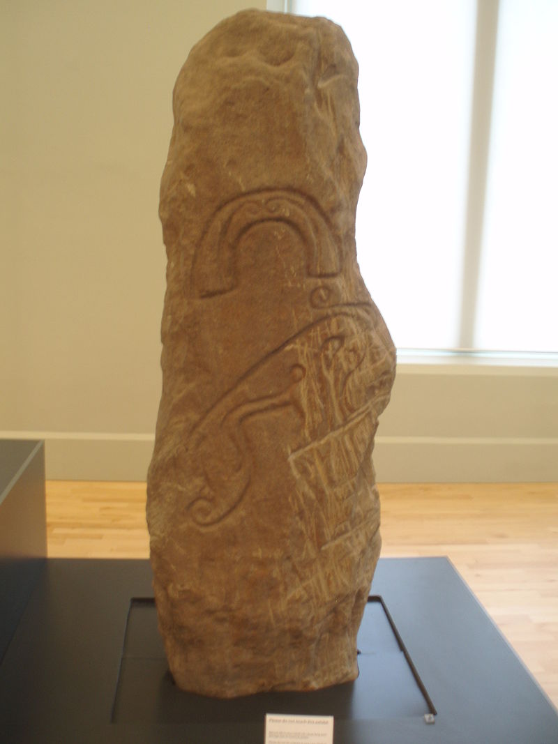
The Picts are renowned for their silverwork and for their many intriguing sculptured symbol stones.
The harpist on the Dupplin Cross, Scotland, c. 800 AD
This 2.5m high stone cross used to stand in Cross Park field near the village of Dunning, Perthshire. It was then removed to the National Museum of Scotland but is now housed in Dunning Kirk. This stone is a must-see, and formed one of the main reasons for the Scottish Megarak meeting of 27th July 2002.
A worn inscription on the back of the cross has been deciphered to indicate that the cross was raised by Constantine, son of Fergus, who reigned as Pictish King from c.789 to 820 AD. The last 10 years of his reign he was also king of Dal Riata in Argyll, and therefore King of Scots too. The cross was erected in the early 9th century overlooking the Pictish royal palace at Forteviot. The symbols carved on it proclaim his kingship and authority, comparing him to the biblical King David, a warrior king much admired by the Picts.
Dr Michael Spearman at the National Museum of Scotland suggests that Dupplin might have been erected by Kenneth Mac Alpin or one of his sons as a suitable dedication to a Pictish king who, like Kenneth himself, had once ruled both the Picts and the Scots with their best interests at heart.
Sutherland describes it thus:
Front: the head of the cross is surrounded by roll-moulding which makes spiral curves at intervals with a raised circular boss in the centre, which has ribbed borders containing cross. Shaft is divided into 3 panels is now to be read as a Latin inscription which translated CUSTANTIN SON OF WUIRGUST (Constantin Mac Fergus); four pairs of birds with their beaks and legs crossed and interlaced round a raised boss full of circular interlace; David rending the lion’s jaw with two other beasts.
Left side: three small panels of interlace on top with three panels down side of shaft; [1] an elaborate beast biting his own tail; a man seated on chair playing a large triangular harp (perhaps David a psalmist and musician); six-cord plait-work.
Back: similar moulding round the cross as on front but the pattern within the central boss is much defaced. The arms are filled with scrolled foliage while at the top find a panel of diagonal key pattern. Three panels on the shaft, separated by key-pattern, show; a warrior with a spear on horseback; four foot soldiers with spears and shields; a hound leaping on a hind.
Right edge: four panels of varied interlace with three panels down the edge of the shaft; a pair of dog-like beasts on their haunches with front paws embracing; two foot soldiers with shields strapped round their necks, holding spears; some knot-work.
http://www.historic-scotland.gov.uk/propertyresults/propertydetail.htm?PropID=PL_270
—-
The Rogart brooch, National Museums of Scotland. Pictish penannular brooch, 8th century, silver with gilding and glass.
This beautiful brooch is one of the few surviving pieces from a large hoard of Pictish metalwork found by a workman in 1868 at Rogart in Sutherland during railway construction. The brooch is of silver with cast gilt interlace decoration made in a technique called chip carving. There are settings for nine studs, all of which are now missing. It dates from the 8th century.

http://archhighland.org.uk/news.asp?newsid=49
—-
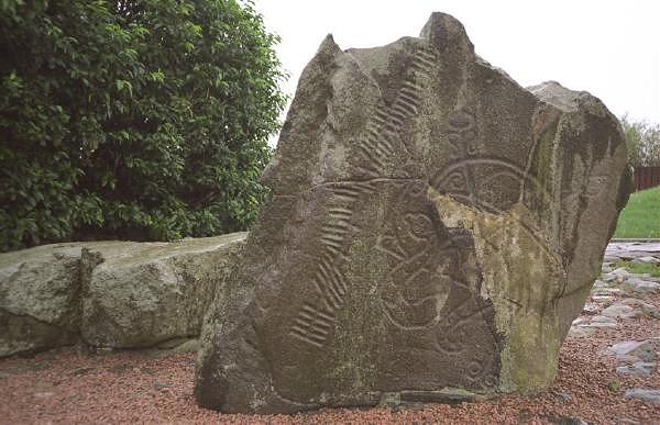
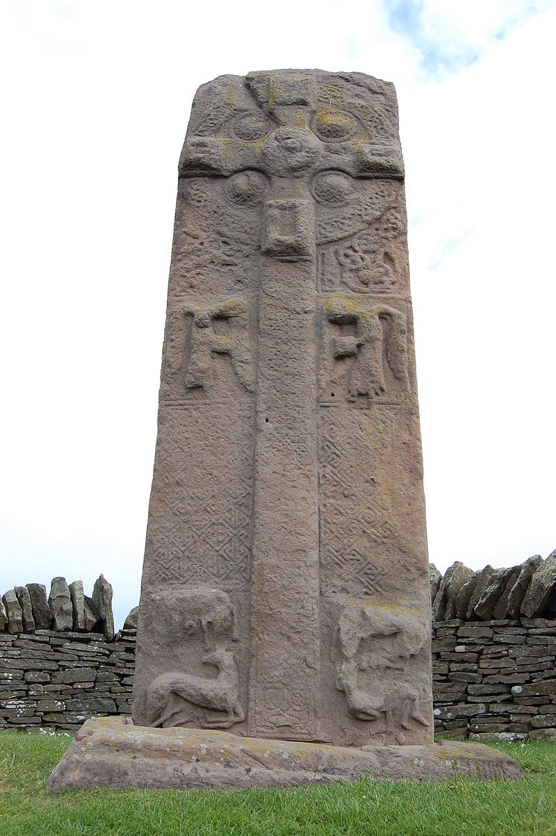
Aberlemno Sculptured Stones
The Aberlemno Sculptured Stones are a series of five Class I and II standing stonesfound in and around the village of Aberlemno, Angus.
Aberlemno 1, 3 and 5 are located in recesses in the dry stone wall at the side of the road in Aberlemno. Aberlemno 2 is found in the Kirkyard, 300 yards south of the roadside stones.In recent years, bids have been made to move the stones to an indoor location to protect them from weathering, but this has met with local resistance and the stones are currently covered in the winter.
Aberlemno 4, the Flemington Farm Stone was found 30 yards from the church and is now on display in the McManus Galleries, Dundee.
Aberlemno 1 is the central roadside stone. It is an unshaped standing stone, bearing incised Pictish symbols, defining it under J Romilly Allen and Joseph Anderson’s classification system as a Class I stone. The symbols on one face: the serpent, the double disc and Z-rod and the mirror and comb. The meaning of these symbols is unknown. They are deeply incised in a bold, confident line, and this stone is considered to be one of the finest and best-preserved Pictish symbol stones still standing in or near its original position. The other face of the stone exhibits prehistoric cup marks, showing that it has been re-used. This stone is known as Aberlemno I or the Serpent Stone.

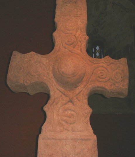
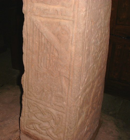
Aberlemno 2, found in Aberlemno kirkyard, is a shaped cross-slab, bearing Pictish symbols as well as Christian symbols in relief, defining it as a Class II stone. The stone, carved from Old Red Sandstone, stands 2.3 metres (7.5 ft) tall, 1.3 metres (4.3 ft) wide at the base, tapering to 0.9 metres (3.0 ft) wide at the top, and is 0.2 metres (7.9 in) thick.
The west face is inscribed with a quadrilobate Celtic Cross. The cross bears several styles of Celtic pattern designs. The vertical arms are inscribed with three separate knotwork designs, the horizontal arms with keywork designs. The central roundel has a spiral design composed of three interconnecting triskeles. Bordering the cross are a number of Celtic zoomorphic designs, reminiscent of Northumbrian designs and designs from the Book of Kells. A hole has been bored through the upper part of the stone some time after its sculpting.
The rear face features two Pictish symbols, a notched rectangle with z-rod and a triple disc. Below this are nine figures which have been interpreted as a narrative account of a battle. On the rear of Aberlemno 2 is a scene showing human figures bearing weapons, apparently engaged in battle. The figures appear in three rows. The top row has an unhelmeted figure on horseback riding behind a helmeted rider, possibly in pursuit. The helmeted rider is armed with a spear and appears to have dropped his sword and shield. The middle row has a helmeted rider armed with a spear and shield facing three unhelmeted infantry soldiers armed with spears, swords and shields. The bottom row shows a mounted and unhelmeted figure and mounted helmeted figure facing each other, both armed with spears. Behind the helmeted rider lies a helmeted casualty, with a bird to his right.

 Aberlemno 3
The western road-side stone is another Class II stone. It has an elaborately decorated ringed cross flanked by adoring angels on one side, and a hunting scene on the reverse, below two large Pictish symbols. This stone is known as Aberlemno 3. This stone has until recently been thought to date from the late eighth century. More recent comparative analyses have suggested that it may be of a later, mid-ninth-century origin.
Aberlemno 3 has different proportions to the Kirkyard Cross-slab, being relatively tall and thin, with parallel sides which have incised decoration (those of the other cross-slab are plain). The monument’s height and decoration on four faces both suggest it is later in date than Aberlemno 2. Its nearest artistic analogies appear to be sculptures from Easter Ross in northern Scotland, notable the Hilton of Cadboll stone (now in the Museum of Scotland), which has a closely similar hunting scene.

Aberlemno 4, the Flemington Farm Stone was found 30 yards from the church and is now on display in the McManus Galleries, Dundee.
Until recently, it was thought to date to the mid-8th century, but subsequent analysis has suggested a mid-9th century date.
This stone, found in 1961 is approximately 1.5 metres tall, 0.5 m wide and 0.3 m thick. It has incised symbols on an unworked stone, defining it under J Romilly Allen and Joseph Anderson’s classification system as a Class I stone. There are two symbols, a horseshoe and a Pictish Beast. The anterior portion of the beast symbol (facing right) has suffered some damage due to ploughing, but is still easily visible.

Aberlemno 5
The eastern Class I stone is highly eroded and the incised symbols are extremely difficult to make out. This stone is thought to be unfinished or a later fake. This stone is known as Aberlemno 5.
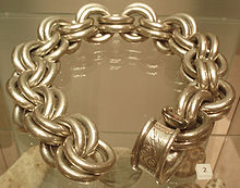
Whitecleuch Chain
The Whitecleuch Chain is a large Pictish silver chain that was found in Whitecleuch, Lanarkshire, Scotland in 1869. A high status piece, it is likely to have been worn as a choker neck ornament for ceremonial purposes. It dates from around 400 to 800 AD.
The chain is one of ten certain examples of this type, and is on display at the Museum of Scotland in Edinburgh.
Weighing 1.8 kg and measuring approximately 50 cm in length, the chain consists of 44 silver rings interlinked into 22 pairs. According to Clark, the chain originally had 23 pairs of rings, but was damaged subsequent to its discovery.)
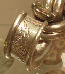
The paired ring chain is augmented by a large penannular ring with expanded flanges. The penannular ring bears Pictish symbols of the sort typically found on Class I and II Pictish standing stones. On one side of the opening in the ring, there is a zigzag pattern and a double disc and Z-rod symbol, on the other side of the opening, there is a notched rectangle symbol, decorated with a pair of circles, running lengthwise along the rectangle and attached to opposite edges of the rectangle. The penannular ring was apparently used as a fastener to link the terminal ends of the chain together into a choker neck ornament.
Reconstructed Crannóg on Loch Tay
The early Picts are associated with piracy and raiding along the coasts of Roman Britain. Even in the Late Middle Ages, the line between traders and pirates was unclear, so that Pictish pirates were probably merchants on other occasions. It is generally assumed that trade collapsed with the Roman Empire, but this is to overstate the case. There is only limited evidence of long-distance trade with Pictland, but tableware and storage vessels from Gaul, probably transported up the Irish Sea, have been found. This trade may have been controlled from Dunadd in Dál Riata, where such goods appear to have been common. While long-distance travel was unusual in Pictish times, it was far from unknown as stories of missionaries, travelling clerics and exiles show.
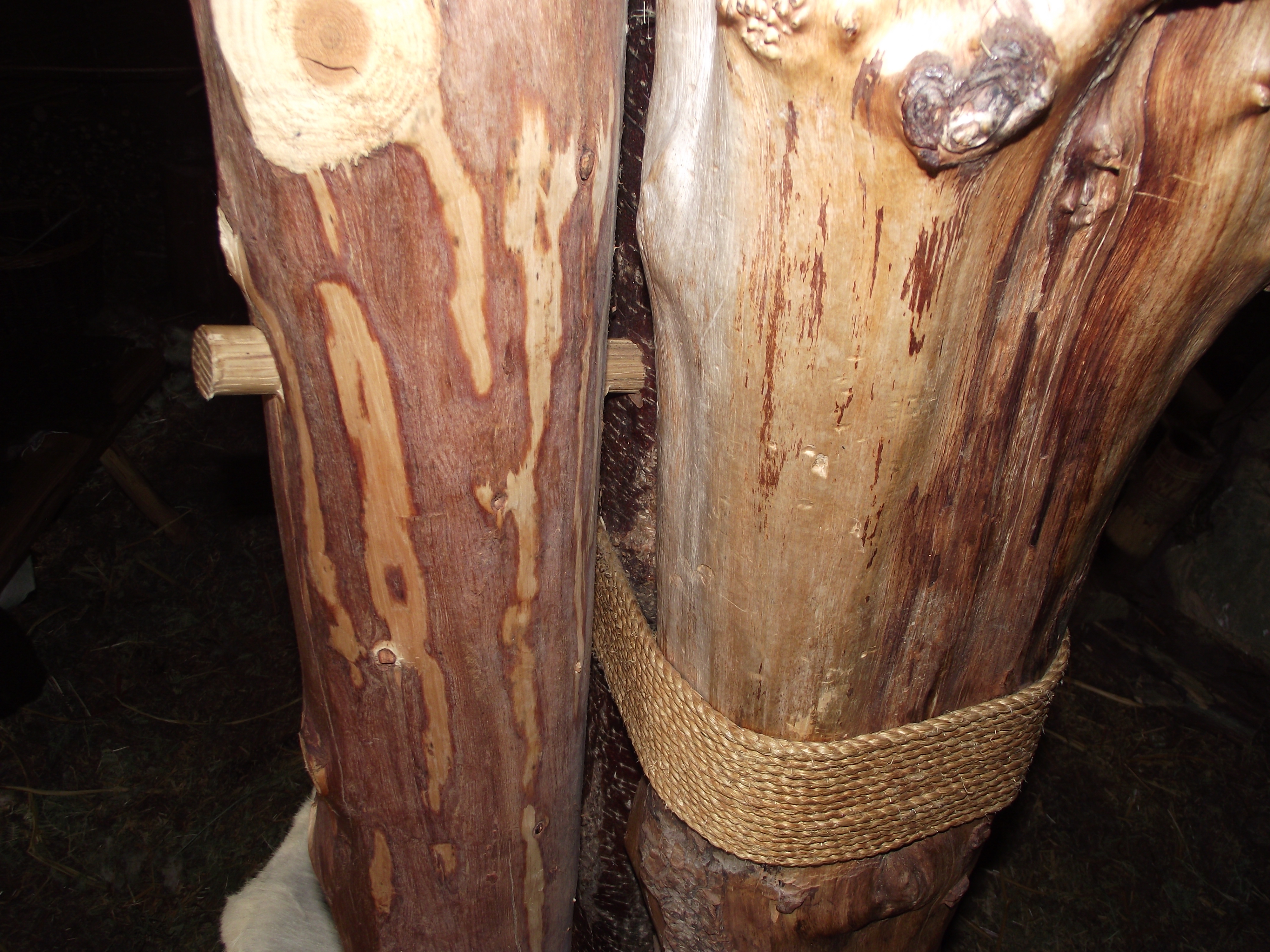
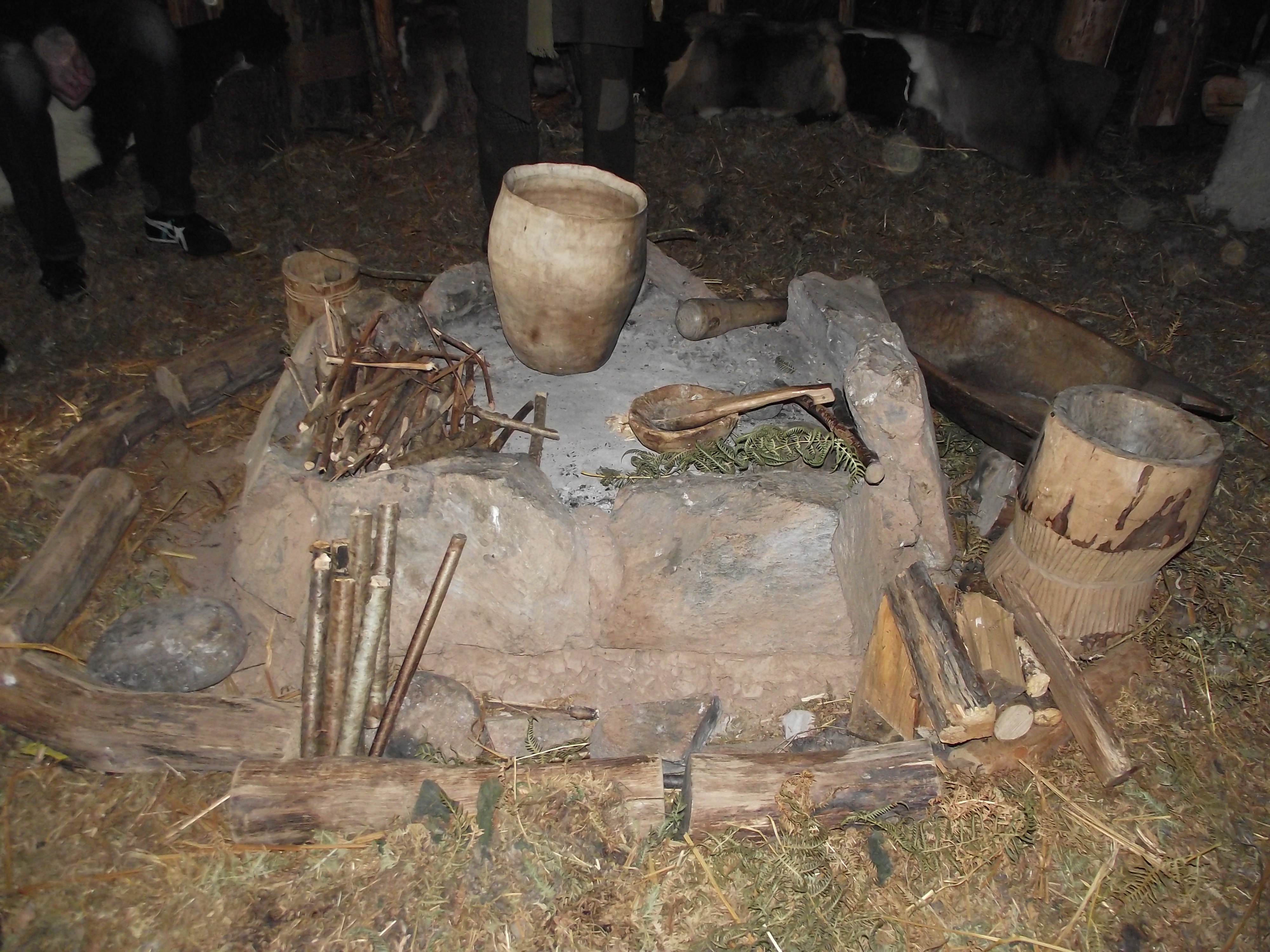
Brochs are popularly associated with the Picts. Although these were built earlier in the Iron Age, with construction ending around 100 AD, they remained in use into and beyond the Pictish period. Crannóg, which may originate in Neolithic Scotland, may have been rebuilt, and some were still in use in the time of the Picts. The most common sort of buildings would have been roundhouses and rectangular timbered halls. While many churches were built in wood, from the early 8th century, if not earlier, some were built in stone.

The archaeological record provides evidence of the material culture of the Picts. It tells of a society not readily distinguishable from its similar Gaelic and British neighbours, nor very different from the Anglo-Saxons to the south.
There is no denying the fascination of the Pictish people.
 2015 Opening times: